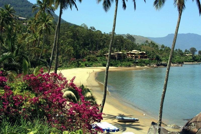
Ilhabela, Sao Paulo, Brazil
Suggest Place to Visit
488
Track to location with GPS |
 |
The Municipality of Ilhabela comprises: São Sebastião Island, Búzios Islands, Vitória Island (inhabited), and more islets: das Cabras (also inhabited), Serraria (in front of the beach of the same name), Castelhanos, lagoon, Figueira (in Castelhanos bay) and Enchovas (in Enchovas bay).
The island of São Sebastião received its name on January 20, 1502, given by Amerigo Vespucci, a name alluding to the saint of the day, when he passed through this channel.
The city of São Sebastião appeared much later. Historians say that the village of São Sebastião had as its first name Vila da Ilha de São Sebastião, therefore, Ilhabela is the name of the municipality, the Island (geographical accident) is Ilha de São Sebastião.
The village of the Island was named Villa Bella da Princesa. It achieved its political-administrative emancipation on September 3, 1805 under this name. It was renamed just Villa Bella (popularly) without any legal measure (decree) for this change. It remained with this name until 1940, when, by decree, it changed its name to Formosa, and in 1944 to Ilhabela. The name Ilhabela is therefore 65 years old.
The population of the municipality of Ilhabela has always been concentrated in the strip close to the sea, mainly in the channel part, although the caiçara has lived until today, all around the island, mainly on the beaches and more sheltered places.
Until the 50's the population of the municipality was genuinely caiçara. From there, the first migrants and tourists begin to arrive, these coming mainly from the capital of São Paulo. And so it is that some families of tourists who acquired properties here on the Island at that time and even before 50, keep them to this day, such as Vila Caiçara, Engenho D'água, Garapocaia, Ponta das Canas, Catatau.
Tourism developed more intensively from the 60's (with the advent of the ferry in 1958). From then on, until today, the municipality has been equipped with good commerce, focused on tourism.
Until the forties, the municipality of Ilhabela had good agricultural activity, developing mainly the planting of sugar cane for the manufacture of pinga, so famous and preferred.
In the fishing area, the municipality had a well-developed activity, mainly in sardine fishing, which was carried out on a large scale. Also with regard to agriculture, coffee, banana, orange, avocado, cashew, jackfruit, beans, corn and manioc were planted.
A good amount of this production was taken to Santos, to be marketed, through the large vogue canoes (rowing), and by the boats that maintained a periodic line to that city and from there to here. Currently, the economy of the municipality of Ilhabela is focused only on tourism.
Source: Pindavale/cities in the regions
Ilhabela is on the northern coast of the state of São Paulo. It is 190 km from São Paulo (another 15 minutes by ferry); 435 km from Rio de Janeiro (plus 15 minutes by ferry); 6km from São Sebastião (another 15 minutes by ferry); 116km from São José dos Campos plus 15 minutes by ferry). Access to Ilha Bela is via Ferry Boat through the Port of São Sebatião. Ilha Bela has a humid tropical climate and a temperature of 22° to 23°C.
Source: Ilhabela.com
Ilhabela has a state park that will guarantee for future generations an important sample of the rich biodiversity found in the Atlantic Forest, one of the most beautiful vegetation in Brazil.
You can find some trails like:
Água Branca – 2,145 meters long, it is the most signposted trail on the island, with rest points for outdoor picnics and identification of the different species of trees. Delicious waterfalls and natural pools refresh the walk. It starts at the guardhouse in the State Park, on the Castelhanos road.·
Laje – leaving the car at the southern end of the road (Sepituba), a 40-minute walk towards the Bonete beach takes you to Cachoeira da Laje. The course of the river forms some falls, slides and beautiful natural pools.
Baepi - climbing the Pico do Baepi (1,025 meters of altitude) is a challenge of 4 hours of steep walk through the forest. An authorization from the Park administration is required, as well as the accompaniment of guides. Climbing on rainy days should be avoided. On a clear and cloudless day, the view from the peak reaches the Ilhabela mountain range, the channel and much of the Serra do Mar.
Poço - It is at the end of the road to the north of the island. After Jabaquara beach, following a trail close to the coast for 4 hours, you reach Poço beach, where a waterfall tumbles into the sands, forming a freshwater pool.
Ilhabela has a lot of water, wind, beach of all kinds. These ingredients make Ilhabela a center for water activities such as yachting, windsurfing and diving.
Source:virtuallibrary/tourism-ilhabela
Comments
We don´t have yet any comments about:
Ilha Bela - General Information
Ilha Bela - General Information
Be the first to leave a comment as it is very important to inform other people
Outros locais a visitar
Within a radius of 20 km from:Ilha Bela - General Information
Unfortunately we do not have information on other places to visit in this area yet
Hotel reservation near Ilha Bela - General Information within a radius of 20 km
No results
Why to book with CLUBE TRAVEL
The best prices
Our partnerships with the world´s largest operators offer research on the best market prices.
More options
At Rotas Turisticos you can book the hotel, buy the air ticket, book the transfer from the airport to the hotel and vice versa, book the local excursions, rent the car, take travel insurance and consult the places to visit and where to go.
Holiday Tips & Destinations
Hundreds of holiday destinations with all the options that allow you to easily choose the destination that best suits your dream vacation.
CLUBE TRAVEL
Links


